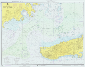
 In the world of oceanography, people live by nautical charts. It is considered one of the most fundamental tools that a mariner can have access to. Why is charting water so important? Because it allows you to see a variety of information that may help you navigate the waters with ease.
What Information is Revealed?
These charts depict the shoreline, but it goes much deeper than that. Literally. On each map, you will see:
- Water Depths
- Hidden Dangers (sunken ships or coral reefs that have grown to the surface)
- Locations of Places
- Anchorages Areas
- and More…
When to Use a Nautical Chart
 You should use a nautical chart anytime that you plan to go on a voyage in the water, but they are mostly designed for large ships or yachts that may be heavier than most boats so that they can travel safely. In fact, commercial vessels must always have them on board if they plan to enter into U.S. waters. Private vessels are not required to have access to these charts, but it may still be recommended.
Where to Get a Local Nautical Chart?
Since the 1830s, the NOAA or some variance of the same organization, has been the main chart maker for the U.S. If you are seeking past or present maps of your local area, you can contact NOAA or your local coast guard department for more information. Then, your biggest challenge will be to learn how to read it.